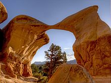
The Grand Staircase-Escalante National Monument is a U.S. National Monument protecting 1,880,461 acres (760,996 ha) of land in southern Utah. There are three main regions: the Grand Staircase, the Kaiparowits Plateau, and the Canyons of the Escalante - all of which are administered by the Bureau of Land Management as part of the National Landscape Conservation System. President Bill Clinton designated the area as a national monument in 1996 using his authority under the Antiquities Act. Grand Staircase-Escalante encompasses the largest land area of all U.S. National Monuments.
The Monument is managed by the Bureau of Land Management rather than the National Park Service. This was the first National Monument managed by the BLM. Visitor centers are located in Cannonville, Big Water, Escalante, and Kanab.
The Monument stretches from the towns of Big Water, Glendale and Kanab, Utah on the southwest, to the towns of Escalante and Boulder on the northeast. Encompassing 1.9 million acres, the monument is slightly larger in area than the state of Delaware.
The western part of the Monument is dominated by the Paunsaugunt Plateau and the Paria River, and is adjacent to Bryce Canyon National Park. This section shows the geologic progression of the Grand Staircase.
The center section is dominated by a single long ridge, called Kaiparowits Plateau from the west, and called Fifty-Mile Mountain when viewed from the east. Fifty-Mile Mountain stretches southeast from the town of Escalante to the Colorado River in Glen Canyon. The eastern face of the mountain is a steep, 2200 foot (650 m)escarpment. The western side (the Kaiparowits Plateau) is a shallow slope descending to the south and west.
East of Fifty-Mile Mountain are the Canyons of the Escalante. The Monument is bound by Glen Canyon National Recreation Area on the east and south. The popular hiking, backpacking and canyoneering areas include the Canyons of the Escalante, shared with Glen Canyon National Recreation Area and Skutumpah and Cottonwood Roads. Highlights include the slot canyons of Peekaboo, Spooky and Brimstone Canyons, the Devil's Garden, Bull Valley Gorge, Willis Creek, Lick Wash and the backpacking areas of lower Coyote Gulch and of Harris Wash.
The Hole-in-the-Rock Road extends southeast from the town of Escalante, along the base of Fifty-Mile Mountain. It is important in the history of The Church of Jesus Christ of Latter-day Saints and the settlements of southeast Utah, including Bluff, as well as providing access to the Canyons of the Escalante, and to the flat desert at the base of Fifty Mile Mountain that is used for grazing cattle.


